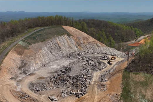
Route 58 Expansion
In Patrick County, VA, a 7.4-mile section of Route 58 is widening from two lanes to four to accommodate increased economic development in the region. This $300-million Public-Private Transportation Act (PPTA) project also provides safety improvements on the portion of roadway over Lovers Leap.
Stakeholders include the VA Department of transportation (VDOT, owner); Branch Civil, Inc. (BCI, PPTA contractor); Whitman Requardt and Associates (WRA, designer and geotechnical co-consultant), ECS Group of Companies (ECS, geotechnical co-consultant) as well as commercial trucks and the traveling public.
ECS’ role
ECS provided preliminary geotechnical exploration and recommendations for rock cut slopes and catchment ditches, soil cut slopes and embankment slopes for VDOT. ECS also supported additional geotechnical exploration and final recommendations alongside the designer, WRA, for final design and construction through a PPTA process executed by BCI.
During construction, geotechnical staff conduct regular site visits to observe ongoing rock-slope excavation to address variability in the geologic conditions, with field modifications performed as warranted. Rock probes performed by the contractor are also utilized to explore possible changing locations.
Unique challenges and solutions
Much of the site is characterized by steep, mountainous terrain requiring tall cut slopes and fill embankments extending up to narrow ridge tops and down to valley floors. The site is underlain by variable bedrock conditions, ranging from rock outcrops to deep, weathered rock zones.
Site stats
- Lovers Leap is the steepest of three remaining sections to be widened on Route 58.
- Max cut slopes more than 200 ft in height.
- Max fill slopes more than 300 ft in height.
- Approximately 1,500 ft of grade change along alignment.
Sampling and analysis
Steep terrain and significant rock outcrops warranted a combination of traditional soil borings, rock coring and strength testing for soil and rock samples with structural mapping of existing rock outcrops, seismic refraction, in-situ televiewer mapping and in-situ borehole shear testing to characterize variable bedrock and overburden conditions. In addition to kinematic analysis of rock cuts, global stability analysis of cuts included modeling of soil overburden, mass rock and rock-joint characteristics considering reliability for parameters of each.
Analyses were performed to reduce rock excavation and meet safety requirements for the traveling public. Additionally, a portion of the eastbound lane widening was bifurcated from the mainline where grades were steepest to improve grade for truck traffic by allowing the downgradient lanes a more favorable path.
Innovation and impact
BCI performs regular drone flights during construction to document ongoing excavation activities. This data allows for efficient analysis and modifications based on geotechnical staff observations as rock slope excavations progress. Modifications are made as warranted to maintain safety for the traveling public.
Results and lessons
Collaborative interaction between the contractor and geotechnical and design staff allows for verification that exposed field conditions meet design expectations, particularly given the variable and mountainous site. This supports VDOT’s goal of engineering safer rock slopes along Route 58.
Related Projects
Loudoun County Health Department
Third-party hydrogeologic review for public health oversight Loudoun County, Virginia relies on private wells and groundwater systems to...
Learn More
Tarrant County College
Assessing 327 roofs across 2.5M square feet using drones Across eight campuses in Fort Worth, Texas, aging roofing...
Learn More
Keys Energy Center
Storm + groundwater remediation for power plant redevelopment near protected wetlands The proximity of the Keys Energy Center...
Learn More
East Palestine Railroad
Environmental support following a railway chemical release in East Palestine East Palestine, Ohio became a focal point for...
Learn More
Cleveland Clinic Global Peak Performance Center
Materials testing and Special Inspections for a 210,000 sq foot practice facility Situated within a $3.5 billion riverfront...
Learn More