You’ve almost reached the current capacity of your municipal water supply.
Many municipalities have a combination of resources to meet their community’s water supply needs, including wells and surface water sources. Based on your increased usage demand, you need to identify new water supply sources – and fast. That’s a major problem, and you have no idea where to turn. Residents and developers don’t know about the situation yet, but unless a solution can be found, they’ll know soon enough.
The local government and economic development authority also know they’re facing a big issue, but they have no idea how to address it. Rainfall has been spotty, and seeing the impact that the severe drought in the West is having on those communities has everyone worried. What can they do?
They can reach out to a hydrogeologist.
What is a Hydrogeologist?
I’m sorry – a what?
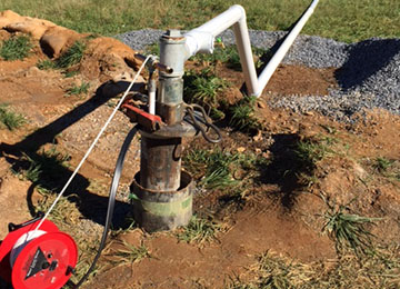
A hydrogeologist is an engineering professional who can help locate and develop new high-yield groundwater wells. They can also assist with groundwater protection planning for current water supply sources. Hydrogeologists are the Sherlock Holmes of geotechnical and environmental engineering. They look for clues that help pinpoint the possible existence of large reservoirs of water deep beneath the ground.
Hydrogeologists begin by conducting a geology review. They conduct a field reconnaissance, looking for features in the topography that may suggest good potential for a high yielding well site. The team looks for zones of fractured bedrock where groundwater may exist. They often utilize geophysical surveys, because water filled fractures conduct electricity differently than rock and soil.
Hydrogeologists also look at local well records and review hydrogeological reports from surrounding properties. They examine aerial photography using a Stereo Scope to help identify topographical features that were not obvious from the field visit. And just like Sherlock Holmes, they start putting all these facts together to arrive at a possible solution.
Now they have all the facts. What happens next?
Tune into our next blog post to find out!